


So what to do on the “Big One”? It had to include cycling, but it had to be close enough to fit into an already tight July calendar. And, since my husband was footing the bill, it had to include some good eating! A couple of years ago, I read about a woman who rode 70 miles on the Silver Comet Trail near her home in Alabama to celebrate her 70th. Since I had never ridden more than 44 miles in a single day, well, you can do the math . . .
The Champlain Islands are a popular destination for cyclists and just up the road from our home in New Hampshire. Well, two and half hours at 65 mph up an interstate highway. I knew that if I wanted a quick special getaway for the “big one,” this was the place to go. My husband and I had biked there before, so I knew that we could get in a good two days of riding on my favorite types of routes—waterfront ones. Putting aside thoughts of how many candles were going to be on the cake (if I had one), I had expectations for a “champagne experience.
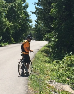
We rarely travel anywhere during high season–and it doesn’t get any higher than July in New England. Fortunately, my big day fell on a Wednesday, so I knew that if we planned our routes carefully, we could enjoy hours of riding in clearly marked bike lanes in light traffic.
Since we had only two full days on this trip, for our first ride, we chose a route north of the North Hero Inn where we were staying, and another south of it for the second.
Day 1–North to Canada
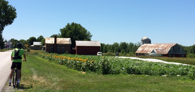
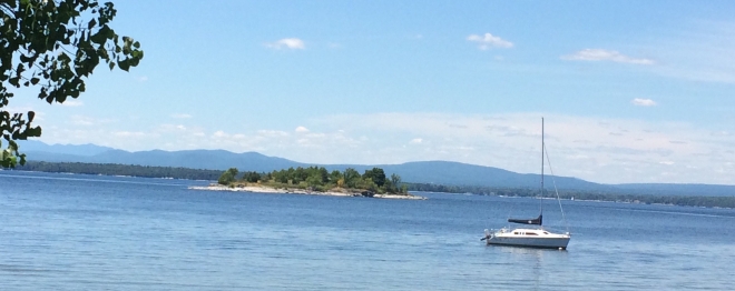
Cycling the first mile north of the North Hero House on Route 2 is like having dessert before the meal. Just over the guardrails, waves lap the rocks and views of the eastern shore of Lake Champlain tempts cyclists’ eyes to stray away from the road. There’s a mirage of civilization on the distant shore, but for a few moments, it is just me, a few ducks, and the sound of the waves–and my husband not far behind.
As I round a curve, the lake on our right, I shift gears as the route climbs gently through a sparsely populated area of homes and farmland. The route swerves farther away from the shore, but views of the lake shine through the modest lakefront home. I envy the people who live in this little piece of paradise.
The six miles to the bridge that connects North Hero with Alburgh, VT is relatively flat. The key word here is “relatively,” as this is Vermont. We reach the bridge that connects North Hero Island with the peninsula with the funny name of Alburgh Tongue. It stretches down from Canada, and on a map, it does look like a tongue sticking out into the lake. On this day, a fisherman claims the bike lane as his fishing spot.
After a consult with Google maps, we follow Route 129, the second left over the bridge. The first left goes to Isle LaMotte, a route we’d done on a previous trip. Route 129 is a 3-mile stretch that connects both shores. With lots of rolling hills. On the downhills, I feel like a kid (Look, Ma, no hands.), but like the senior citizen I am on the longer climbs.
At its end, we are rewarded with a literally breathtaking ride along West Shore Road for roughly 4.5 miles. Strong winds are blowing off the lake–refreshing on a hot day, but creating some resistance as we pedal north. Hopeful that Alburgh, near the Canadian border, has a quaint cafe or bistro where we can relax, we hunker down over our handlebars until we reach Route 2. Lucky for us, this part of Route 2 is perfectly flat. However, the bike lane narrows to the span of our handlebars and traffic increases. An eighteen wheeler passes us, and then a pickup towing a boat the size of small yacht.
But a refuge is in sight. The Alburgh Welcome Center that we remember visiting a previous bike trip is just ahead. Welcome Center = bathrooms plus WiFi. And cold water.
At the Center, a woman replenishing the Center’s Free Little Library recommends a family diner just “a couple miles away” over the New York border. A Google search shows that it was actually four miles away, i.e. an 8 mile round trip. Our only other option nearby is a Subway. We decide to retrace our route to a country club we passed on West Shore Road. A quick call to the club and a woman confirms that, yes, cyclists are welcome, even in Spandex or in my husband’s case, his baggy bike shorts.


The 19th Hole Bar & Grill Restaurant at the Alburgh Country Club is an oasis–one with an extensive selection of beers on tap, including some craft brews. The large patio overlooking the course with a view of the lake beyond is just the place for a birthday–or any other–lunch.
Nourished and rested, we have the wind at our back on the return to North Hero. A steep hill just minutes from the country club is the only obstacle on an otherwise easy ride. The climb is very short, but there is no way to build momentum. So still sated with a hearty lunch complete with hard cider for me and a couple of beers for my husband, we have no pride; we walk up the hill in blistering early afternoon sun. Once over that hill, the rest of the ride back to the inn is 45 minutes of pure exhilaration along a now familiar route.
Our total mileage for the day is 31 miles—not quite the 44 that we had done several years before when we amused two young Canadian customs officials with our reason for crossing the border on bikes: “Just so we can say that ‘we biked to Canada.'”
I don’t bike 70 miles, nor into another country this day, but it is a pretty good ride for the “big one.”
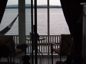
My reward? A relaxing dinner at the inn and a toast to my “champagne day” on our porch overlooking the lake.
Day 2–South to Vineyards and Farmlands
After a “champagne” day, there is bound to be a bit of hangover, but not on this trip. There are still so many roads to ride. The entire Champlain Islands Bikeways system has close to 1,000 miles of routes. Oh, if only I had started on my 20th birthday!
We had biked the five short loops there on our previous trips, so we decide to again chart our own. With an 11 a.m. checkout, our first challenge is finding somewhere to park the car for the day. We choose Grand Isle State Park, a campground on the eastern shore of Grand Isle where we leave our car in a (free) parking area outside the entrance gate. The park has restroom facilities outside the gate and snacks and beverages for sale in season.
Heading out of the park a short ways, we turn right onto N East Shore Road where we enjoy a ride through a residential area. I say “residential,” but some of the properties are well off the road, with hidden driveways. I have my first real biking scare when a UPS driver hits his brakes just feet away from me as I cross a drive hidden by trees. That truck is the only vehicle that passes us on this 2-mile stretch, however. A short half-mile ride in light traffic on Route 2 brings us to mile-long Hyde Road where we ride through beautiful countryside with working farms and almost no traffic. At the end of Hyde, we turn onto Addams School Road (unmarked) for a short while before turning at the tiny Quaker Cemetery onto Quaker Road–probably the most spectacular mile I’ve ever ridden on two wheels. There is a gentle uphill climb, but then the most exhilarating descent with a gorgeous view of the New York side of the lake. It’s definitely picture-worthy, but it’s a choice between enjoying the view on a fast ride downhill or stopping. I choose the ride.
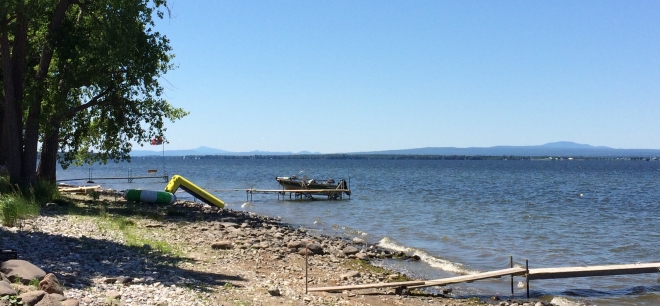
For a few moments, I think that nothing can match that view. But, I am wrong. We turn left onto West Shore Road and are again hugging a waterfront and awesome views of the Adirondack Mountains.
Now, here’s where it gets tricky. Google maps shows that we should follow West Shore Road until looping back to the east side of the island. However, we come to a T stop, not marked, of course, with any street sign. Fortunately, a motorist comes by who directs us to the right to South Hero. (Ironically, a trucker had stopped before him, asking us for directions to the ferry to New York state.) The “T” is Route 314, or West Shore Road. There’s a long hill to climb, but it is quite easy-going even for a senior birthday girl.
Over the hill aways, we pass the Champlain Adult Campground and have some fun speculating what that might be. Next, the ferry station to New York State, and more working farms and lots of attractive lakeside homes. This route definitely has its ups and downs and weaves near and away the shoreline. We have a mid-route destination–Snow Farm Vineyard & Winery. We had stopped there on a previous trip, but fine wine is not in the cards this trip. Nor in our panniers. When we–and lots of other cyclists–arrive, Vermont PBS staff are getting ready to shoot a program from the winery.
So, it is off to West Shore Road again for a few more miles, and more rolling hills. As we approach the intersection of West Shore Road and South Street, a parade of cyclists from the Local Motion ferry cycle past. We turn left and follow them, and a huge John Deere tractor, into the center of South Hero.
By this juncture, we have given up hope of finding a cafe or restaurant and have resigned ourselves to picking up ready-made sandwiches (Ugh!) at a convenience store on Route 2. Oh, ye, cyclist of little faith! Just a mile up South Street, a culinary treat awaits us at the apple orchards of Allenholm Farm. Attached to the farm’s store is an true outdoor cafe, The Accidental Farmer where they grill and cook outdoors and diners sit at picnic tables. It is a cyclist’s mecca. The hamburgs are made with locally sourced grass-fed beef and grilled to perfection. On Friday evenings during summer, the burgers are served up with live music.
Continuing on South Street (well fed and hydrated) for a mile, we reach Route 2 where we turn left and cycle three miles, much of them uphill. This is a busy stretch of Route 2 in the summer, so we take a detour onto Town Line Road, a short road that leads through residential areas and intersects with S East Shore Road.
From S East Shore Road, State Park Road is on the right and the end of this fun 20-mile loop through Grand Isle.
As for the “champagne experience”? It wasn’t as long or elaborate as the trip for my previous “big one” when we biked to Versailles via Paris–but that’s a story in itself. My birthday in Vermont had all the bubbles, but it’s just the prelude to the real birthday present–a 10-day bike tour of Poland. Stay tuned.
For tips on planning your own fun trip to these islands, read Six Secrets to Successful Cycling in the Champlain Islands.
And for my suggestions for where to stay and wine and dine, read Pedal, Dine, Sleep, Repeat.
